


Voting District 09, Surry County, North Carolina
About
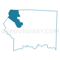
Outline

Summary
| Unique Area Identifier | 641448 |
| Name | Voting District 09 |
| County | Surry County |
| State | North Carolina |
| Area (square miles) | 42.03 |
| Land Area (square miles) | 41.87 |
| Water Area (square miles) | 0.17 |
| % of Land Area | 99.60 |
| % of Water Area | 0.40 |
| Latitude of the Internal Point | 36.48752990 |
| Longtitude of the Internal Point | -80.87407080 |
Maps


Graphs
Select a template below for downloading or customizing gragh for Voting District 09, Surry County, North Carolina


Neighbors
Neighoring Voting District (by Name) Neighboring Voting District on the Map
- Voting District 01, Surry County, NC
- Voting District 03, Surry County, NC
- Voting District 04, Alleghany County, NC
- Voting District 25, Surry County, NC
- Fairview Voting District, Grayson County, VA
- Oakland A Voting District, Carroll County, VA
Top 10 Neighboring County Subdivision (by Population) Neighboring County Subdivision on the Map
- Dobson township, Surry County, NC (8,860)
- Piper Gap district, Carroll County, VA (7,864)
- Stewarts Creek township, Surry County, NC (7,169)
- Fancy Gap district, Carroll County, VA (5,075)
- Old Town district, Grayson County, VA (4,160)
- Bryan township, Surry County, NC (2,747)
- Franklin township, Surry County, NC (2,400)
- Glade Creek township, Alleghany County, NC (1,991)
Top 10 Neighboring Place (by Population) Neighboring Place on the Map
Top 10 Neighboring Unified School District (by Population) Neighboring Unified School District on the Map
- Surry County Schools, NC (56,264)
- Carroll County Public Schools, VA (30,042)
- Grayson County Public Schools, VA (15,533)
- Alleghany County Schools, NC (11,155)
Top 10 Neighboring State Legislative District Lower Chamber (by Population) Neighboring State Legislative District Lower Chamber on the Map
- State House District 5, VA (69,572)
- State House District 10, VA (68,822)
- State House District 90, NC (65,180)
Top 10 Neighboring State Legislative District Upper Chamber (by Population) Neighboring State Legislative District Upper Chamber on the Map
Top 10 Neighboring 111th Congressional District (by Population) Neighboring 111th Congressional District on the Map
Top 10 Neighboring Census Tract (by Population) Neighboring Census Tract on the Map
- Census Tract 9308.01, Surry County, NC (5,201)
- Census Tract 601.02, Grayson County, VA (4,157)
- Census Tract 9501, Alleghany County, NC (4,079)
- Census Tract 9308.02, Surry County, NC (3,176)
- Census Tract 806.01, Carroll County, VA (2,017)